- Date:
- 17 Sept 2021
The feedback received on the discussion paper has supported the Fire District Review Panel in determining the suitability of, and subsequently evolving, the fire risk methodology. The Fire Rescue Victoria Fire District Review - Finalisation of Proposed Risk Assessment Methodology paper addresses stakeholder feedback provided on the discussion paper and outlines the resultant fire risk assessment methodology.
The consultation period for the proposed risk assessment methodology has now closed
Thank you to everyone that shared their insights with us. Your valued contribution is crucial as the Fire District Review Panel undertakes this important piece of work.
We received 68 responses to online survey and 13 formal submissions from our key stakeholders.
The feedback provided during the consultation period will support the Panel in determining the suitability of the proposed fire risk methodology.
The Panel will engage with the community and key stakeholders further as the review progresses.
A program of reforms is underway which sets out the government’s vision for Victoria’s fire services – a modern, integrated and sustainable system that responds to the evolving needs of communities.
As part of these reforms, the Fire District Review Panel (the Panel) has been established to undertake reviews of the Fire Rescue Victoria (FRV) fire district boundaries at least once every four years. The current review is to be completed and recommendations made to the Minister for Emergency Services by 30 June 2024.
The Panel has published the Fire Rescue Victoria Fire District Review - Proposed Risk Assessment Methodology Discussion Paper which outlines the proposed risk assessment methodology that will be used to undertake the review of the FRV fire district boundaries.
Summary
The Victorian Government is continuing to reform the state’s fire services based on recommendations from the 2009 Victorian Bushfires Royal Commission and other subsequent reviews.
As part of the reform, the Fire District Review Panel (the Panel) has been established to undertake reviews of the Fire Rescue Victoria (FRV) fire district boundaries at least once every four years. The current review is to be completed and recommendations made to the Minister for Emergency Services (the Minister) by 30 June 2024.
The Minister may also request additional reviews of any FRV fire district boundaries to address location specific issues and emerging risks.
Following the Panel’s recommendations, any change(s) to the FRV fire district boundaries will be determined by the Minister.
The Panel is an independent public entity that commenced on 1 July 2020. It is bound by legislative obligations under section 4 of the Fire Rescue Victoria Act 1958.
Its remit is to provide independent advice to the Minister on whether drivers such as population growth, service demand, land use and climate change are altering the fire risk, and whether these changes mean the FRV fire district boundaries need to be adjusted.
Accordingly, this discussion paper describes the proposed approach for undertaking a quantitative risk assessment as the basis for determining recommendations to the Minister.
As part of the review process, the Panel will consult with all relevant stakeholders, including fire agencies and local government. This discussion paper is the first step in the consultation process. It outlines the proposed risk assessment methodology to be used for reviews and invites feedback.
To have your say:
- read the discussion paper and supporting appendices
- consider the proposed risk assessment methodology
- share your thoughts by completing the survey. The survey closes 5pm on Friday 19 November 2021.
Introduction
Reform of Victoria’s fire services
The fire services arrangements in Victoria had their origins in the 1890s. The introduction of the Metropolitan Fire Brigades Act 1958 and Country Fire Authority Act 1958 modernised these arrangements.
Since that time, the fire service arrangements remained largely unchanged until July 2020 when the Metropolitan Fire Brigades Act 1958 was superseded and replaced by the Fire Rescue Victoria Act 1958 (the Act). The Country Fire Authority Act 1958 remains in force.
The Victorian Government recognises that the fire services arrangements must be reviewed to ensure that they meet the needs of a rapidly changing state, and while progress has been made, work is continuing to fully deliver on the recommendations of the 2009 Bushfires Royal Commission and subsequent reviews.
A program of reforms is underway which sets out the government’s vision for Victoria’s fire services – a modern, integrated and sustainable system that responds to the evolving needs of communities. Four priorities have been set:
- Priority 1: Restore the Country Fire Authority (CFA) to a volunteer- and community-focused organisation.
- Priority 2: Establish Fire Rescue Victoria (FRV) to lead firefighting in major regional cities and Melbourne.
- Priority 3: Plan and build for the future.
- Priority 4: Value our firefighters.
The Fire District Review Panel
As part of Priority 3: Plan and build for the future, the independent Fire District Review Panel (the Panel) was established on 1 July 2020 by the Act with the obligation to discharge functions under section 4 of the Act.
As an independent public entity, the Panel comprises of three members who report directly to the Minister for Emergency Services (the Minister).
Scope of the Fire Rescue Victoria fire district review
Victoria is serviced by both FRV and the CFA, who are each responsible for areas within their defined fire district boundaries.
The Panel’s remit is to provide independent recommendations to the Minister on any changes to FRV fire district boundaries based on changes to fire risk.
The Panel will conduct a risk assessment of the assignment of responsibility necessary for the provision of fire services by fire services agencies, in order to prevent, and protect against, loss of life and damage to property, infrastructure or the environment. Section 4 outlines the factors involved in this proposed risk methodology.
Purpose of this discussion paper
This discussion paper is the first step in the Panel’s consultation on the reviews of the FRV fire district boundaries. It outlines the proposed methodology for the risk assessment and seeks to gather feedback from stakeholders.
The Fire Rescue Victoria fire district boundaries
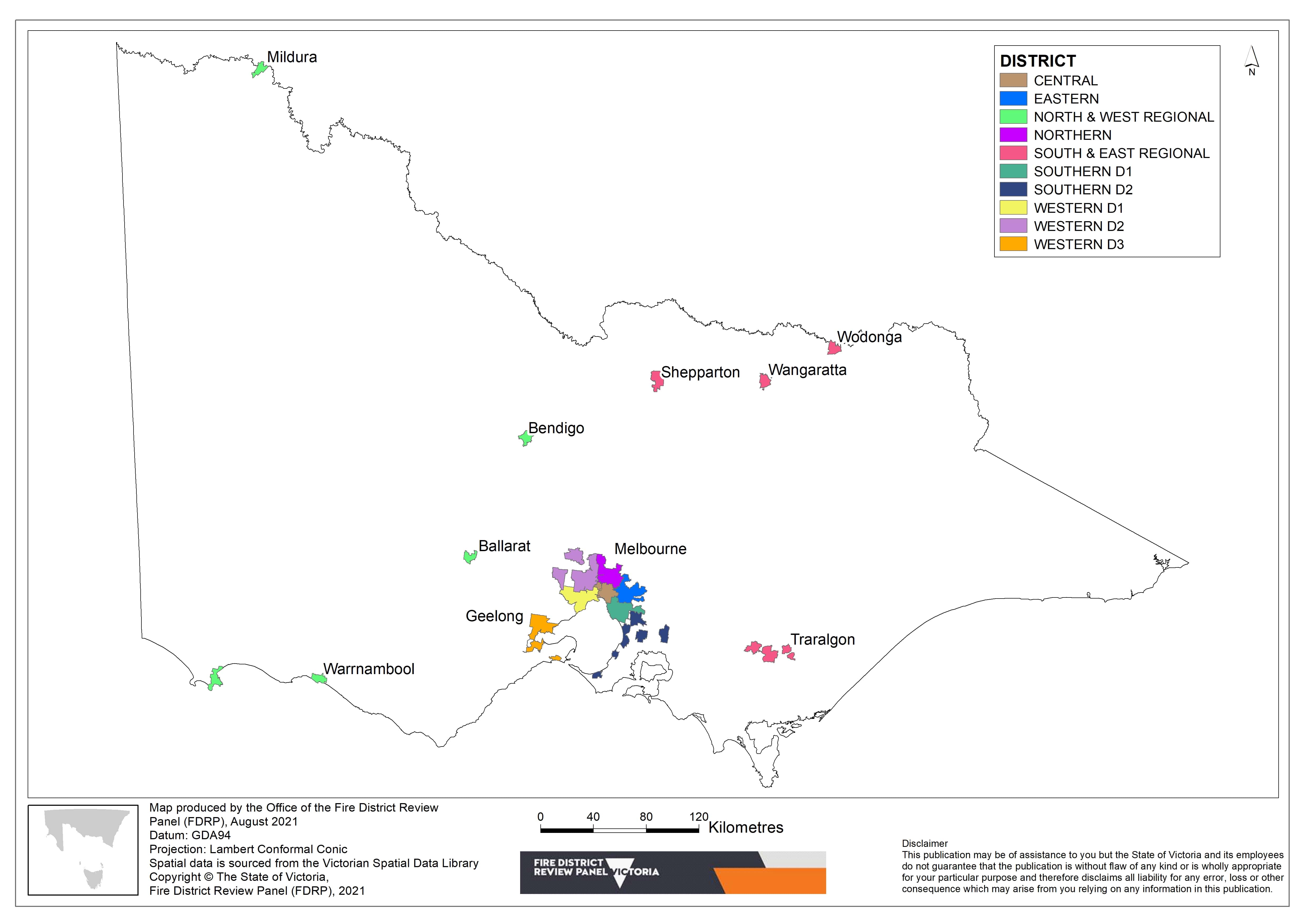
These fire district boundaries demarcate FRV’s fire services response areas across Victoria (Figure 1).
There are 10 FRV districts with 85 stations across these. Each station has an associated response area, and the majority are within Greater Melbourne.
Review process
What is the timeframe for the review?
Section 4G of the Act requires the Panel to conduct reviews of the FRV fire district boundaries at least once every four years. Further, the Panel is also required to conduct reviews of any FRV fire district boundaries within a specified timeframe upon the request of the Minister.
The current four-year review period commenced on 1 July 2020 and will be completed by 30 June 2024.
How will changes to the FRV fire district boundaries be decided?
The Panel will conduct risk assessments, based on key risk drivers, and consult with relevant stakeholders in order to determine whether any FRV fire district boundaries need to be changed.
Once the risk assessments and consultations are complete, the Panel will publish the determination of proposed changes to the FRV fire district boundaries in the Victorian Government Gazette.
The CFA will be provided further opportunity to advise on their support arrangements to volunteer brigades to ensure that they have the capacity to respond effectively to the change in fire risk prior to the Panel reporting its recommendations to the Minister.
The final determination on any changes to the FRV fire district boundaries will be made by the Minister.
Overview of the proposed risk assessment methodology
Overarching themes
The Panel is developing a methodology to assess the risk load serviced across the state by FRV and the CFA.
The following themes have guided the development of the proposed risk methodology:
- safety and wellbeing: protecting life, property and environment
- clear, transparent, evidence-based methodology
- fire service capacity and capability
- time frame for change
- community expectations and needs
- impact and consequence analysis
- legacy projects and issues
- aligned with the State Emergency Management arrangements and other overarching policy and management principles
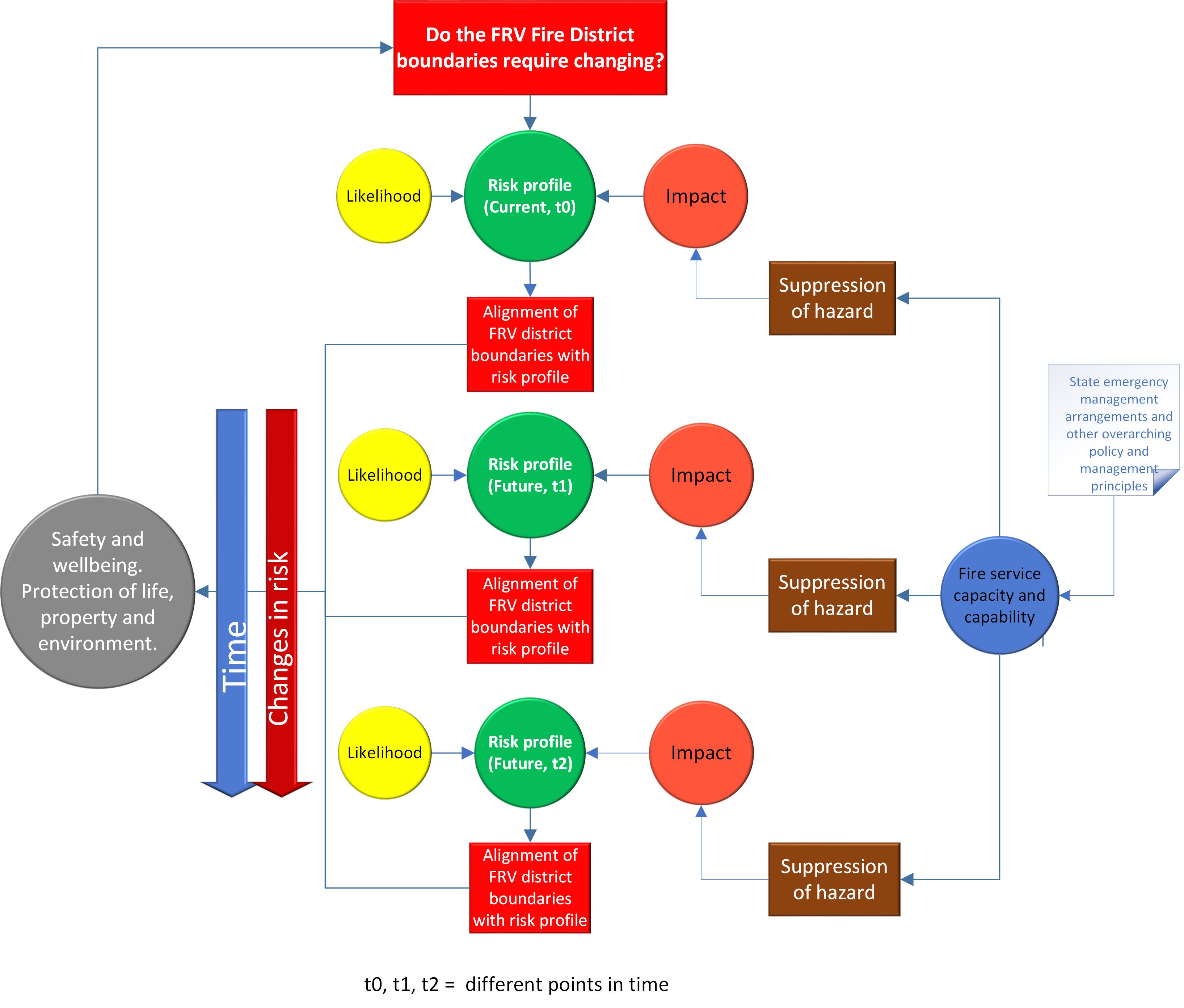
The high-level schematic diagram (Figure B.1 in Appendix B), which represents changes in the risk profile over time, broadly references these themes. The State Emergency Management Priorities are also relevant and will be considered.
What is risk?
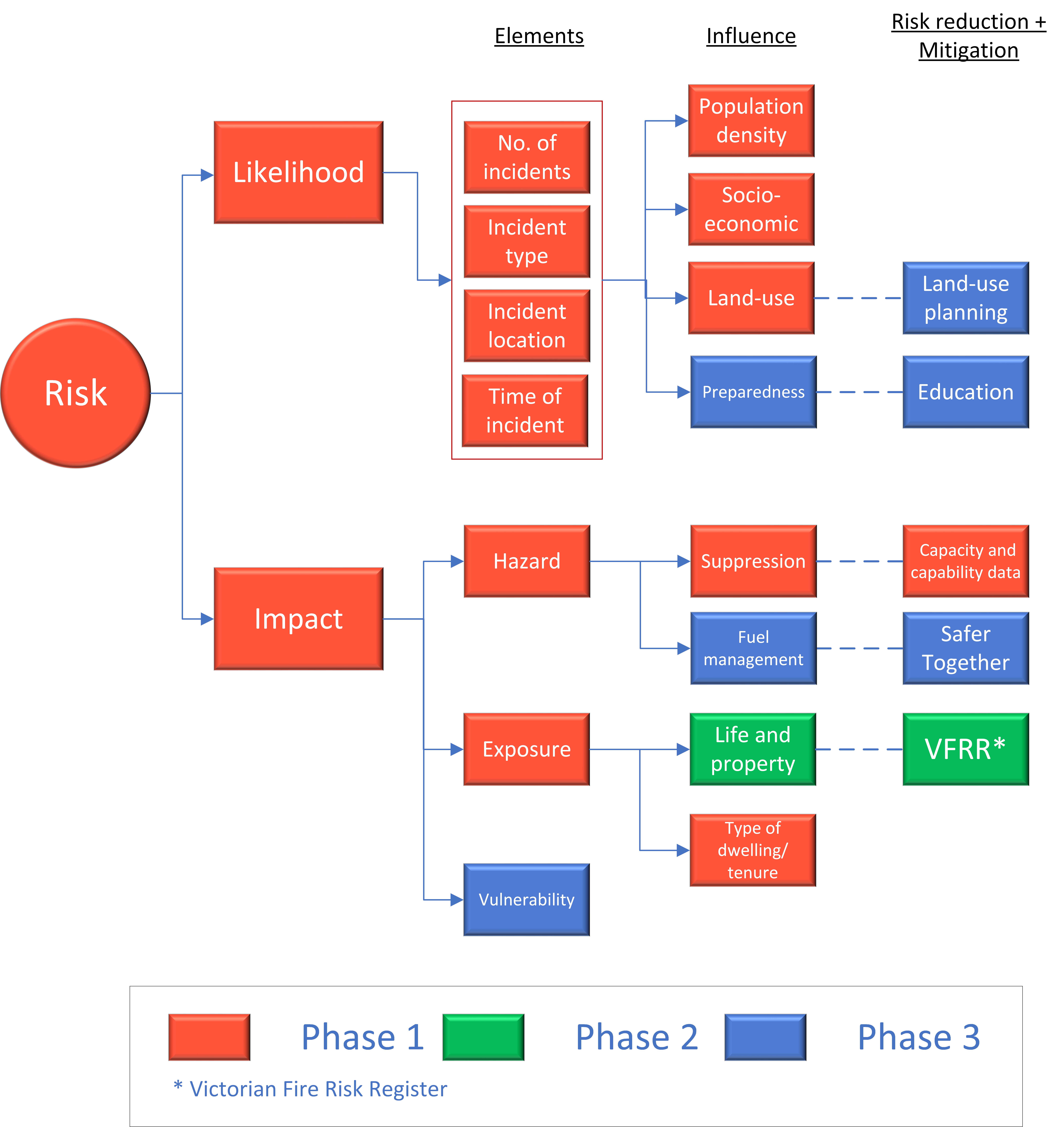
The risk of fire can be assessed by considering both its likelihood and impact (Appendix A: Theoretical risk overview). The likelihood of fire is examined as a function of past fire history. The impact of fire is understood by considering the elements of impact (hazard, exposure and vulnerability). The Panel addresses hazard by means of the fire services’ capacity and capability to suppress the fire hazard. Exposure refers to the location information and attributes of dwellings, communities, buildings, structures, infrastructure assets, agricultural commodities, environmental assets and business activity. Vulnerability refers to the impact a hazard has on people, infrastructure and the economy. Vulnerability can be classified according to four types: physical, social, economic and system.
Fire incident likelihood (probability) is independent of severity of impact of fire.
Assessment of risk
The assessment of the risk serviced by FRV and the CFA is complex. As these organisations respond not only to fire but also to other emergencies, they encounter several types of risk (e.g., fire, hazardous material, road accidents) that require different equipment and skill sets. Furthermore, these risks vary over space (e.g., population density, socioeconomic factors, land use) and time.
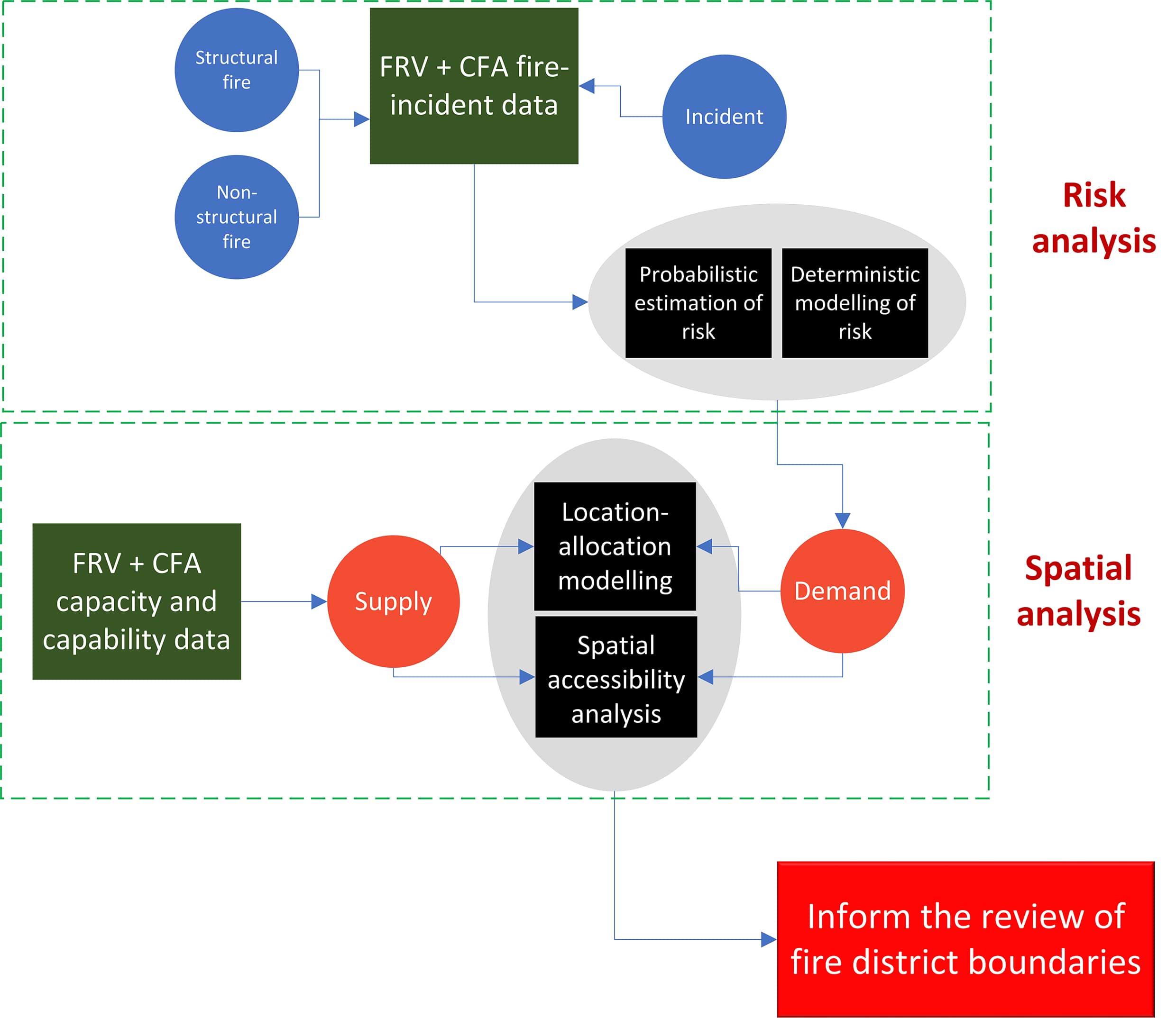
Theoretical risk (likelihood x impact), as outlined in Appendix A, can be translated into an operational context (illustrated by Figure B.2 in Appendix B). The likelihood of fire will be examined using historic FRV and CFA incident data from 2010–2021. This data will be classified according to the type of incident (residential fire, non-structural fire etc.) and used to develop statistical models, and subsequent risk layers for each type of incident. This representation of risk across Victoria will be subject to further spatial analysis (Figure B.3 in Appendix B).
The process of building these risk models for each type of incident requires an understanding of the possible factors that explain the spatial and temporal patterns of fire risk. In the case of a residential fire, they can often be attributed to human factors and socioeconomic circumstances. The composite Index of Relative Socioeconomic Advantage and Disadvantage (IRSAD) integrates these characteristics. Exposure information, including type of dwelling and tenure status, will also considered in the model. Further, spatial indicators such as residential mobility, residential density and level of proficiency in English can be used to explore how readily information will diffuse within a local population, which has implications for the temporal distribution of risk.
Other types of incidents, such as industrial fires, accidents and hazardous material, cannot be explained as simply using socioeconomic data. The drivers behind these incidents are less apparent, and specific neighbourhood characteristics of the incident are unavailable or deficient. In such cases, land use spatial datasets, such as transportation (e.g., airports, railways, roads and harbours) and industrial developments, can be used in combination with exposure and vulnerability datasets to understand the distribution of risk.
The Panel will endeavour to develop as many incident-specific models as required; however, as fire is the Panel’s primary focus, fire models will be developed first.
Much of the academic research in fire risk assessment has addressed solely the likelihood of fire1,2,3, largely due to an absence of detailed impact data (exposure and vulnerability), such as costs of fires, construction materials, or the presence of invalids, elderly persons or children in a building. The Panel will endeavour to integrate impact data in the modelling as the work progresses in phases.
Phasing
Due to the magnitude and complexity of the proposed risk assessment, the process will be undertaken in phases.
Phase 1 will consider likelihood, where the incident data will be integrated with a range of variables that drive risk. Hazard suppression information (FRV and CFA capacity and capability data) will also be integrated in Phase 1 through spatial analysis that examines travel impedance (i.e., distance or time), facility busyness, coverage, and the ratio between the supply and demand of services (Figure B.3, Appendix B).
Phase 2 will incorporate additional exposure information, while Phase 3 will draw on risk information from the Safer Together program4 and attempt to integrate state-wide fuel management risk data. This is an important element of the state’s risk quotient, requiring yearly updates and of critical importance, particularly in the peri-urban fringe, which is vulnerable to bushfire and thus a major concern for regional fire managers.
Population growth and land use planning
As Melbourne and regional centres across the state become more populated and infrastructure is established to accommodate this, the quantum of risk changes. These changes in risk will be assessed (as described in Section 4.3 above) in conjunction with population forecasts, and future land use and development planning (including community, commercial, industrial and residential development).
Knowledge and datasets from Land Use Victoria and the Planning Division of the Department of Environment, Land, Water and Planning (DELWP) will be incorporate in the risk assessment.
Climate change
Climate change will potentially result in variations in the distribution of risk across the state. It may alter weather patterns, environmental conditions and ecosystem function, with implications for the sector’s ability to undertake established disaster mitigation activities. For example, specific conditions are required to ensure that prescribed burning on private land to reduce fuel load can be carried out safely and effectively. Rising temperatures, increasing fuel availability (through drying), growing awareness around smoke issues and CO2 emissions, and less-predictable wind conditions may all contribute to reduced safe planned burning opportunities (AFAC 2018)5. Resourcing pressure, due to increases in frequency and intensity of bushfires, also impacts the overall ability of the fire services to mitigate risk in a bushfire.
The Panel aims to work closely with DELWP, through Safer Together6, to understand how climate change is impacting fuel accumulation and, subsequently, risk across the state.
Adjustment of the FRV fire district boundaries according to risk analysis
Risk layers, generated from the proposed risk models, will be input into spatial accessibility and location allocation‑ modelling (Figure B.3, Appendix B).
Spatial accessibility is a measurement of the spatial connection between the supply and demand of services. Spatial accessibility analysis is used to examine how accessible fire services are to the community. This knowledge is essential for ensuring an efficient operational response and reducing injuries and deaths. Accessibility involves two elements: regional availability and regional proximity. Regional availability means the ratio of supply to demand for each demand location (the physical location where risk is quantified). Regional proximity accounts for the spatial interactions between supply and demands sides. For the spatial accessibility analysis, in the Victorian context, the capacity of the fire services represents the supply, while the quantum of risk is the demand. Areas of high fire risk make a greater demand on fire services than areas of low fire risk.
Location-allocation modelling is a process designed to find the optimal location for service provision across a city or region given the spatial distribution of demand for that service. In the context of the fire services, location-allocation can be used to maximise the coverage of fire stations such that the maximum number of demand areas are covered by the specified response time standard.
Similar to spatial accessibility, supply and demand are integral to the process.
Footnotes
- https://www.researchgate.net/publication/228770569_Locating_fire_stations_in_Belgium_An_integrated_GIS_approach
- https://www.researchgate.net/publication/329948437_Modeling_Spatial-Temporal_Dynamics_of_Urban_Residential_Fire_Risk_Using_a_Markov_Chain_Technique
- https://www.researchgate.net/publication/259129919_Discovering_spatio-temporal_relationships_in_the_distribution_of_building_fires
- Safer Together is the approach to reducing the risks of bushfire in Victoria that combines stronger community partnerships with the latest science and technology to more effectively target our actions. More information is available at https://www.safertogether.vic.gov.au/understanding-risk
- Australasian Fire and Emergency Service Authorities Council 2018. Climate Change and the Emergency Management Sector: Discussion Paper. AFAC, Melbourne, Australia.
- Safer Together is the approach to reducing the risks of bushfire in Victoria that combines stronger community partnerships with the latest science and technology to more effectively target our actions. More information is available at https://www.safertogether.vic.gov.au/understanding-risk
Appendix A: Theoretical risk overview
Risk is the likelihood of damage/loss from the hazard, integrated across the entire spectrum of possible events:
Risk= f( likelihood, impact)
Impact or consequence is based on the interaction of the fire characteristics and the vulnerability of the asset to fire.
Impact= f(hazard, exposure, vulnerability)
The direct impact of the event is calculated from the costs modelled across all exposures during the event. If we examine the elements of impact:
- Hazard is a physical situation with a potential for undesirable consequences to people, property or the environment. It refers to the fire, accident or incident that the fire service is responding to.
- Exposure refers to what elements are at risk (people, buildings, infrastructure, agriculture etc.)
- Vulnerability refers to how each exposed element responds to the level of hazard. Vulnerability can be divided into four main areas: physical, social, economic and system.
Appendix B: Technical schematic diagrams
Fire District Review Panel - Frequently asked questions
What is the Fire District Review Panel?
The Fire District Review Panel (the Panel) is an independent public entity that commenced on 1 July 2020. It was established by and is bound under legislative obligations set out in the Fire Rescue Victoria Act 1958 (Vic).
Who does the Fire District Review Panel report to?
The members of the Panel are appointed by the Minister for Emergency Services, and the Panel provides independent advice to the Minister.
What is the role of the Fire District Review Panel?
A program of fire services reform is underway to fully deliver on the recommendations of the 2009 Victorian Bushfires Royal Commission and subsequent reviews.
As part of this reform in Victoria, the Panel was established to conduct reviews of the Fire Rescue Victoria (FRV) fire district boundaries and provide independent advice to the Minister for Emergency Services on whether changes to fire risk mean that the FRV fire district boundaries need to be adjusted.
When are you going to review the Fire Rescue Victoria fire district boundaries?
The Panel will undertake reviews of the FRV fire district boundaries at least once every four years. The current four-year review period commenced on 1 July 2020 and will be completed by 30 June 2024.
The Minister may also request additional reviews of any FRV fire district boundaries to address location specific issues and emerging risks.
How are you going to review the Fire Rescue Victoria fire district boundaries?
As part of the review the Panel will conduct quantitative risk assessments, based on key drivers, and consult with relevant stakeholders in order to determine whether any FRV fire district boundaries need to be changed.
These risk assessments will consider how the drivers of fire risk, such as population growth, service demand, land use and climate change are altering the fire risk across the state, and whether these changes mean the FRV fire district boundaries need to be adjusted.
The Panel has published the Fire Rescue Victoria Fire District Review - Proposed Risk Assessment Methodology Discussion Paper which outlines the proposed risk assessment methodology for undertaking reviews of FRV fire district boundaries.
Who are you consulting with as part of the review?
As part of the review process, the Panel will consult with all relevant stakeholders, including fire agencies and local government.
The Panel has published the Fire Rescue Victoria Fire District Review - Proposed Risk Assessment Methodology Discussion Paper which outlines the proposed risk assessment methodology to underpin its reviews. Feedback is encouraged via the structured survey in the discussion paper link above.
The Panel will continue to engage and consult with stakeholders as it undertakes reviews of the FRV fire boundaries across the state.


